Log In
/-81.341915130615,31.31852111885,12/500x250?access_token=pk.eyJ1Ijoid2F0ZXJ3YXlndWlkZSIsImEiOiJGRmM1RDdzIn0.Wya5yV5QEqbz0-fct8zyIA)
GA: Altamaha Sound by R204, MM 658
- Date Reported: Jun 18, 2024
- Reporter: Bob423
- Source: User
- Description:
Update: 6.9 MLLW as of 1/12/2024 on the Bob423 track.
This area has been dredged, and the Bob423 track has been adjusted to follow the centerline of the dredged channel. Follow the Bob432 track as shown on the 10/20/2022 USACE survey. Note that the red ATONs are far from the channel, 325 feet for R204. Many boats have run aground by getting too close to the reds.
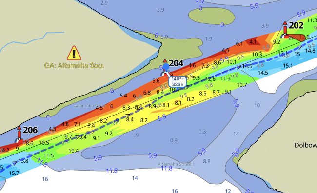

USACE = US Army Corps of Engineers
ATONs = Aids TO Navigation such as buoys and daymarks
Aqua Map = a navigation app for Apple and Android devices
Bob423 Long Track = blue dotted line
How to download tracks - Lat / Lon: N 31° 19.111' / W 081° 20.515'
DISCLAIMER: Waterway Guide Media provides Navigation Alerts as a resource for planning purposes only and does not warrant the information included in the postings as accurate. Advice and descriptions contained in the alerts are not for navigation.


