Waterway Guide Logo
  • SUBSCRIBE
  • Explore
    • Explorer
    • Destinations
    • Marinas
      • Map
      • Directory
    • Services
      • Map
      • Directory
    • Anchorages & Free Docks
      • Map
      • Directory
    • Bridges & Locks
      • Map
      • Directory
    • Navigation Alerts
      • Map
      • Directory
    • Fuel
      • Diesel
      • Gas
      • Fuel Price List
  • Download The App
  • Destinations
  • Knowledge Center
  • Ship Store
    • Ship Store Home
    • Great Lakes Volume 1
    • Great Lakes Volume 2
    • Northern
    • Chesapeake Bay
    • Mid-Atlantic
    • Southern & Gulf Coast
    • Bahamas
    • Cuba
    • Caribbean
  • Urgent Alerts Urgent Alerts
  • Forgot Password?
    Or log in with:
    facebook
    apple
Modal title

Modal body text goes here.

Log In
Forgot Password?
Or log in with:
facebook
apple

Thanks for your valuable feedback!
Back to the Waterway Explorer

View in Waterway Explorer

SC: Isle of Palms, shoaling MM 460 - 461

  • Date Reported: Apr 26, 2025
  • Reporter: Bob423
  • Source: User
  • Description:

    Update: The shallowest part has been dredged!!  The shallowest part is now 6.9 MLLW. 
    The Bob423 track has been updated to go straight through the shallow spot near MM 460. There is no longer a need to take the red dotted line loop south. 


    Note: As of 4/12/2025, there is an uncharted green floating buoy, G117C, off to the port side of the channel when going north. Its approximate location is shown in the photo. Several boats have grounded trying to honor it. G117C is not on any chart or in the light list, ignore it and follow the middle of the newly dredged channel as shown by the blue dotted line (the latest Bob423 track) in the photo. G117C used to mark the channel before dredging, and it has not been moved after dredging

    See the charts below for the status of shoaling at the three shallowest spots as of 4/25/2025


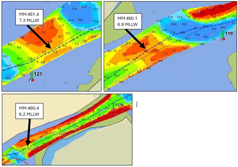
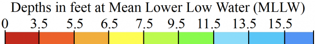
    USACE = US Army Corps of Engineers
    ATONs = Aids TO Navigation such as buoys and daymarks
    Aqua Map = a navigation app for Apple and Android devices
    Bob423 Long Track = blue dotted line
    How to download tracks

  • Lat / Lon: N 32° 47.274' / W 079° 48.391'

DISCLAIMER: Waterway Guide Media provides Navigation Alerts as a resource for planning purposes only and does not warrant the information included in the postings as accurate. Advice and descriptions contained in the alerts are not for navigation.


5 Boater Comments

These are observations from the boating community. Waterway Guide information is verified regularly and all efforts will be made to validate any new updates submitted here. Thank you for taking the time to share comments about your experience.

Waterway Guide reserves the option of editing reviews and comments for grammar, clarity and the removal of defamatory or potentially slanderous language. When appropriate, reviews are forwarded to businesses for response prior to being made public. We will make every effort to be objective and impartial when posting reviews, but do not publicize details of disputes between parties.

Current Review Policies

Waterway Guide reserves the option of editing reviews and comments for grammar, clarity and the removal of defamatory or potentially slanderous language. When appropriate, reviews are forwarded to businesses for response prior to being made public. We will make every effort to be objective and impartial when posting reviews, but do not publicize details of disputes between parties.

  • Comments are reviewed and/or verified by Waterway Guide staff and do not post immediately. Please use a valid email address so that we can contact you if we need clarification (email address will not be published).
  • Name will be published. Anonymous comments may not be posted.
  • Comments will be shared with the reviewed marina to offer them an opportunity to respond. If they choose to do so, the marina’s comments may also be posted in response to the original comment.
  • Comments containing foul or obscene language will be rejected or returned for resubmission.
  • Comments containing personal attacks will be rejected or returned for resubmission.
  • Off-topic content will be rejected.
  • Comments must describe commenter's personal experience – “hearsay” reports will be rejected.
  • Comments must be understandable and clear enough to inform other boaters.
  • URL links are allowed only if they inform the content – no “advertising” your business or blog.

  • Comment by: Mark, Green Voyage, on Dec 18, 2024
    Vessel Type: Sail
    LOA: 38'
    Draft: 5.5'

    Ran hard aground on the blue track 2 hours before low tide. 5.5 draft. MM 460.4. Take the detour!!

    View location on the Waterway Guide Explorer


  • Comment by: Hubert Hopkins on Nov 1, 2024
    Vessel Type: Power
    LOA: 42'
    Draft: 4.0'

    There are two temporary Green buoys 117B and 117C just south of marker 117A at mile 460.3. They are very close to each other. I passed to the north of those and had 6' depth above MLLW. This follows the Bob423 track pretty closely.

    My passage was exactly at low tide with 1' above MLLW so it was very shallow.

    I believe that the "detour" would be less stress for some if the dredge is not blocking the channel. They were not working the day I went through.

    View location on the Waterway Guide Explorer


  • Comment by: Rick Vicars on May 26, 2024
    Vessel Type: Power
    LOA: 45'
    Draft: 5.0'

    5-16-24 No less than 8 ft (low tide) taking the alternate route avoiding the AICW shoaling.

    View location on the Waterway Guide Explorer


  • Comment by: Elizabeth Lenoski, Tranquilo, on May 15, 2024
    Vessel Type: Sail
    LOA: 36'
    Draft: 5.0'

    Came through at 3' tide northbound. Bob alt route had no less than 11' of water. Dredging equipment is set up just south of the bridge and more was being brought in as we passed. Dredge is near center but plenty of space to get by.

    View location on the Waterway Guide Explorer


  • Comment by: Teresa Scott on May 6, 2024
    Vessel Type: Sail
    LOA: 40'
    Draft: 5.5'

    Came through at low tide and used the detour. Lowest we saw was 7.8. A bit nerve wracking especially with a large MV who impatiently had to pass during this.

    View location on the Waterway Guide Explorer

Comment on this Navigation Alert

The name field is required.

The email field is required.

  Display?

LOA is required.

Draft is required.


Yes, sign me up for the News & Navigation Alerts.

Sending...

Review Policies
  • Explorer
  • Download The App
  • Destinations
  • Knowledge Center
  • Shop
Popular Resources
Fuel Price Reports
View the Directory
Subscribe To Our Newsletter
logo
About Us
Contact
Advertise
Careers
Legal
Marina Login
© 2025 Waterway Guide Media LLC: All rights reserved. No part of this site may be reproduced without written permission.
Waterway Guide is proud to be a sponsor of:
aglca
mtoa
seven-seas
us-sailing
abm
Apple Sign-In
Note: If you already have a Waterway Guide account please choose, when prompted, to share your email with us so we can sign you in to your proper account.
 Sign in with Apple
Newsletter Sign-Up

Port is the side of the boat when facing forward.

The captcha question was answered incorrectly.

The email is invalid. Please close the modal window and try again.

Signing-up...