According to Coast Guard District 1, the goals of the reduction in the number of buoys are to:
- Support the navigational needs of the 21st century
- Deliver efficient and economical service to manage vessel transit at an acceptable level of risk
- Better maintain the most critical risk-reducing buoys
- Reduce the risk of Aids to Navigation discrepancies and electronic system failures for those aids most critical to safe navigation.
All of this is against a backdrop of a limited budget. The general approach is to eliminate buoys not essential to navigation, recognizing that modern electronic navigation devices offer more up-to-date charting than traditional systems (paper charts). Some of the proposed buoys for elimination may be replaced with virtual AIS ATONs that are visible to a boat's onboard Automatic Identification System (AIS) device, but there are no details on the number of such buoys or the timing.
The overall thinking seems to be that with fewer buoys to maintain, more attention can be devoted to buoys that are truly critical to navigation, and more resources can be allocated to support the needs of electronic navigation. Coast Guard District 1 is the first to issue a proposal. Other Districts are expected to follow this year.
How to find out which buoys are affected
Detailed instructions are given at Proposed buoy constellation summary, but a summary is below.
Step 1: Go to Maritime Safety Information Products (MSIP) and pan and zoom in on the area of interest in the northeast (Long Island Sound to Maine). You'll need a good internet connection for a reasonable response rate, as the interface is data-intensive.
Step 2: In the upper right corner, click on the layers icon
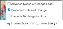
Step 3: In the drop-down menu, select "Proposed Notice of Change Load" (once loaded, the name changes to "Proposed Notice of Change.") Two other options are usually checked automatically: "Physical Map" and "ENCs (NOAA)" but if what you see doesn't match the format of Fig 2, then be sure they are checked too.
 Step 4:
The example from MSIP shows the approach to Bridgeport Harbor, Connecticut. All proposed buoys to be eliminated are indicated by a red or green diamond icon. Only look at Coast Guard District 1. Other Districts use the same "Proposed Notice of Change" selection for normal buoy discontinuations for other reasons, not as part of the Coast Guard effort to reduce the number of buoys overall. District 1 is first, others will probably later, but not yet.
 If you click on "Data to Table" you will get a detailed description of the change for each buoy in the field of view. The descriptions are the same for all four buoys visible in the chart, except for the buoy name and its corresponding latitude and longitude.
The chart displayed by MSIP is less clear than charts in most navigation apps and chart plotters. For that reason, in the examples to follow, NOAA charts are used as displayed in Aqua Map. It's similar to charts displayed in most apps and chart plotters, and more intuitive. The Aqua Map charts were updated to the latest NOAA level as of May 9, 2025.
Example 1: New Haven Harbor approach
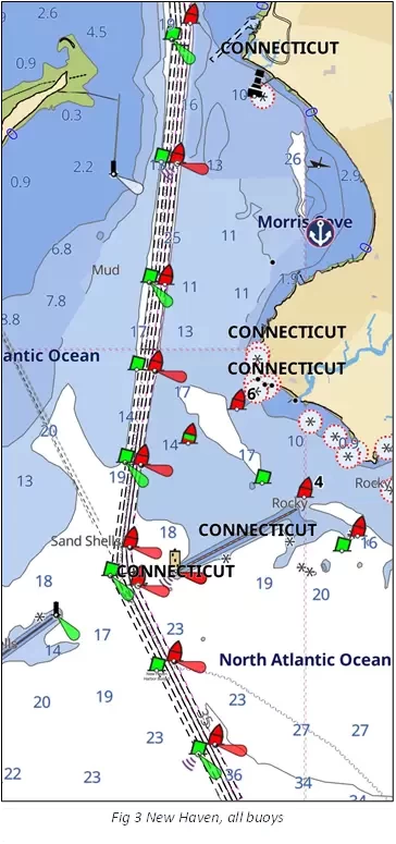

Look at Fig 4 and notice the buoys that are proposed to be eliminated:
- Two buoys south of the breakwaters are to be eliminated.
- Two buoys farther south of the breakwaters remain.
- Buoys at the turn by the breakwaters are not affected.
- Buoys are also proposed for elimination north of the breakwaters, but they alternate between a red and a green, leaving one of the pair to show the channel.
Many of the buoys proposed for elimination follow this pattern, where one of a pair of buoys is removed on a long fairway, but the other half of the pair remains. On especially long fairways, alternating pairs of buoys can be removed.
Question: With virtually all boaters carrying marine navigation devices (MFDs, smartphone apps, tablet apps, etc.), how much does this affect marine safety for the approach to New Haven harbor? Do you consider it unsafe or okay? Will the proposed changes affect your on-the-water navigation? Save your thoughts as additional examples are shown.
Example 2: Woods Hole, Massachusetts
The two charts show the Woods Hole passage with and without the buoys proposed for elimination. The asterisk within a dotted red circle warns of a rock that covers and uncovers with the tides.


The fairways here are short, with many turns, often with fog, vessel traffic, and strong currents. Does the elimination of the buoys impact boater safety? Share your thoughts with the Coast Guard using the contact information provided later in this article.
Example 3: Passage south of Vinalhaven, Maine.

Included here is a route through the hazards as a reference for the buoys to be removed. Note the many buoys marking the narrow channel through the ledges:
- Point Ledge
- Bunker Ledge
- Old Duke Ledges
- Sheep Island Ledge
- Crosby Ledge
- Halibut Ledge
You'll find them slated for elimination in the Coast Guard proposal (see Fig 8)
The buoys proposed for elimination have been removed from the chart in Fig 8. Again, the asterisk within a dotted red circle warns of a rock that covers and uncovers with the tides. You had better have good charts and navigation skills through this area. You will be paying attention to your chart plotter, iPad, or smartphone app rather than looking ahead for buoys (there are none) It will be a challenge in the fog and with the ever-present lobster buoys scattered about, since your attention is divided between a visual lookout and following your chart plotter.

In this article, we've gone from a straightforward removal of alternating buoys on an approach to a harbor to a rather extreme example here with all buoys removed in a narrow passage. Use the Maritime Safety Information Products tool to browse your area of interest for buoys proposed to be removed and plan to be heard.
How to be heard
The Coast Guard is asking for only email replies, with specifics to be addressed. From the announcement: Interested Mariners are strongly encouraged to comment on this in writing, either personally or through their organization. All comments will be carefully considered and are requested prior to 13 June 2025 to complete the process. To most effectively consider your feedback and improve the data collection, when responding to this proposal, please include
- Size of vessel
- Type of vessel
- Recreational or commercial
- Distance from aid that you start looking for it
- How you use the signal.
Please do not call the Coast Guard via telephone or other means; only written responses to this proposal will be accepted. Refer to Project No. 01-25-015. E-mail can be sent to: D01-SMB-DPWPublicComments@uscg.mil.
The time to be heard is now – before June 13, 2025. The proposal to eliminate buoys is currently limited to District 1, specifically the northeast, but other Districts will surely follow.


- 4,000 Marinas
- Thousands of anchorages
- Updated Charts
- Mile-by-Mile Navigation
- Highlighted Alerts & Cautions
- Full-Color Aerial Photographs

The Waterway Guide App Makes it easy to leave reviews, use our explorer, and view waterway guide materials all on the go!


