
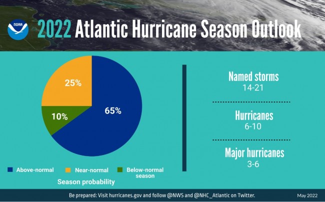
We've often written about hurricanes, great and small. Of note, formerly, an average season produces 12 named storms of which six become hurricanes, including three major hurricanes. As you can see from the table, this year's NOAA prediction will use new numbers for an "average" season: 14-21 named storms, up from 12, and 6-12 hurricanes, up from 6, including 3-6 major hurricanes (Category 3, 4 or 5). Sandy wasn't even a Cat-1, technically.
This column is about rip tides, rip currents and undertows which are what distant storms often leave us - lest one of us comes to grief.
Undertow v Rip Tide v Rip Currents
Anybody that has ever been to a beach understands undertow. It is the backwash as gravity returns a breaking wave to the sea. All but small children can stand against it – and its effect ends at the leading edge of the next breaking wave. While it might knock you down and thus "suck" you under, it won't pull you out to sea. Our mothers didn't know that because they confused undertow with rip tides and rip currents.
A rip tide is the result of tides and the egress and ingress of large volumes of water flowing through inlets, estuaries, and bays. As facts would have it, most people don't swim near inlets or where bays meet the sea. They swim near beaches, where sand bars often form, and where rip currents, "the killer current", form in concert.
The Anatomy of a Rip Current Rip currents are by far the biggest killers of ocean swimmers. Rip currents form as waves disperse along the beach causing water to become trapped between the beach and a sandbar or other underwater feature. This water becomes the "feeder" that creates the deadly force of the rip current. The water converges into a narrow, river-like channel moving away from the shore at high speed. (see exhibit 1)
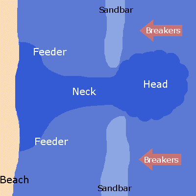
Marine scientists define a rip current as having a "neck" (the river-like channel moving away from the shore) and a "head" that is often defined by an unusual disturbance or choppiness in the water and by murky discoloration caused by sand and debris. As the water, and swimmer, reaches the "head," the velocity and strength of the rip current circulation begins to weaken considerably.
Can I See a Rip Current? Often, yes. As a result of the current's speed, sand is forced into suspension often causing a rip current to be associated with "dirty" water. It is characterized by a strong, localized current flowing seaward from the shore; visible as an agitated band of water, which is the return movement of water piled up on the shore by incoming waves.
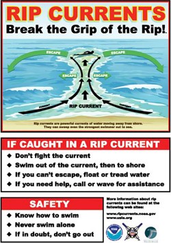
Most Importantly, Can I Get Out of the Grip of a Rip Current? If you don't panic, and play the water's power to your advantage, yes. Don't try to swim back to shore against the rip current that is dragging you out. Most likely, you will tire beyond recovery and drowning, flatly put, will follow as surely as night follows day. Swim with and across the rip current. Let it give you some speed – as you "exit – stage left!" Or right – but get out of the grip of the current and into "normal" water. Then, deal with the hand you've been dealt – swim back, or just tread water while waving your arms for help, or just float and rest. This is why swimming with a "buddy system" is so critical. (See exhibit 2)
If you have any questions about this topic or are interested in being part of USCG Forces, email me at JoinUSCGAux@aol.com or go directly to the US Coast Guard Auxiliary "Flotilla Finder" at http://www.cgaux.org/units.php and we will help you "get in this thing.


- 4,000 Marinas
- Thousands of anchorages
- Updated Charts
- Mile-by-Mile Navigation
- Highlighted Alerts & Cautions
- Full-Color Aerial Photographs

The Waterway Guide App Makes it easy to leave reviews, use our explorer, and view waterway guide materials all on the go!


