Weather App Shootout – Round 2 – Chesapeake Bay
Date Posted: June 5, 2018
Source: Robert Sherer, contributing editor

Editor's Note: Predicting weather and interpreting data from the numerous computer models used by meteorologists is tricky business. Added to that is the way in which various weather apps present information along with the timing of their updates. In this review of five weather apps - PocketGrib, PredictWind, Ventusky, Windy and Windfinder Pro  - Contributing Editor Bob Sherer conducted a simple evaluation based on his experience on a particularly windy day.


Here we go again! Why can't my apps predict the weather on the Chesapeake Bay? We were headed north from Hampton, VA to the Mill Creek Anchorage inside Ingram Bay at the southern end of the Great Wicomico River at Reedville, VA, a distance of about 55 n.m. We were expecting 10 to 15kts according to the NOAA marine forecast, but winds were averaging 17kts with gusts to 23kts. Being such a small area, I thought it would be easy to forecast the winds accurately.

I had my usual array of iPad weather apps at the ready and recently added Windfinder Pro, following a suggestion from a reader in my Round 1 review. Before leaving Hampton, I took screenshots of the apps to determine which one was closest to what I was about to experience. (A description of each of the apps can be found in my first review Weather App Shootout - Round 1.)
 
In this Round 2 review are the apps' predictions for 11:00 AM on Sunday, 5/20/2018, for the area we sailed north on the Chesapeake Bay. The apps are shown in the same order as presented in Round I.


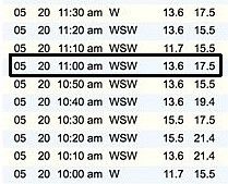
First, here is the real-time wind data from the York Spit buoy, which is located about 12 miles north of where we left and six miles south of New Point Comfort.

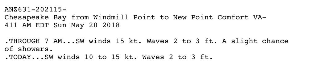
The official NOAA marine forecast for the Chesapeake Bay early that morning was 10 to 15kts. The NOAA forecast winds were accurate once I got underway, but with higher gusts. The forecast area is in one of the widest sections of the Bay. Note that the forecast is presented with a time delineation for the period through 7 AM and afterward.   


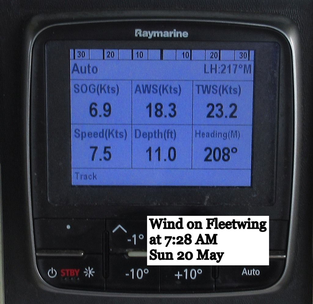
At 7:28 a.m. I experienced 23 kt gusts, as you can see from the photo of my wind gauge. Below are comparisons of the apps' predictions that I screenshot before getting underway. I used the True Wind Speed (TWS) indicator on my instruments throughout the day to measure the variances.


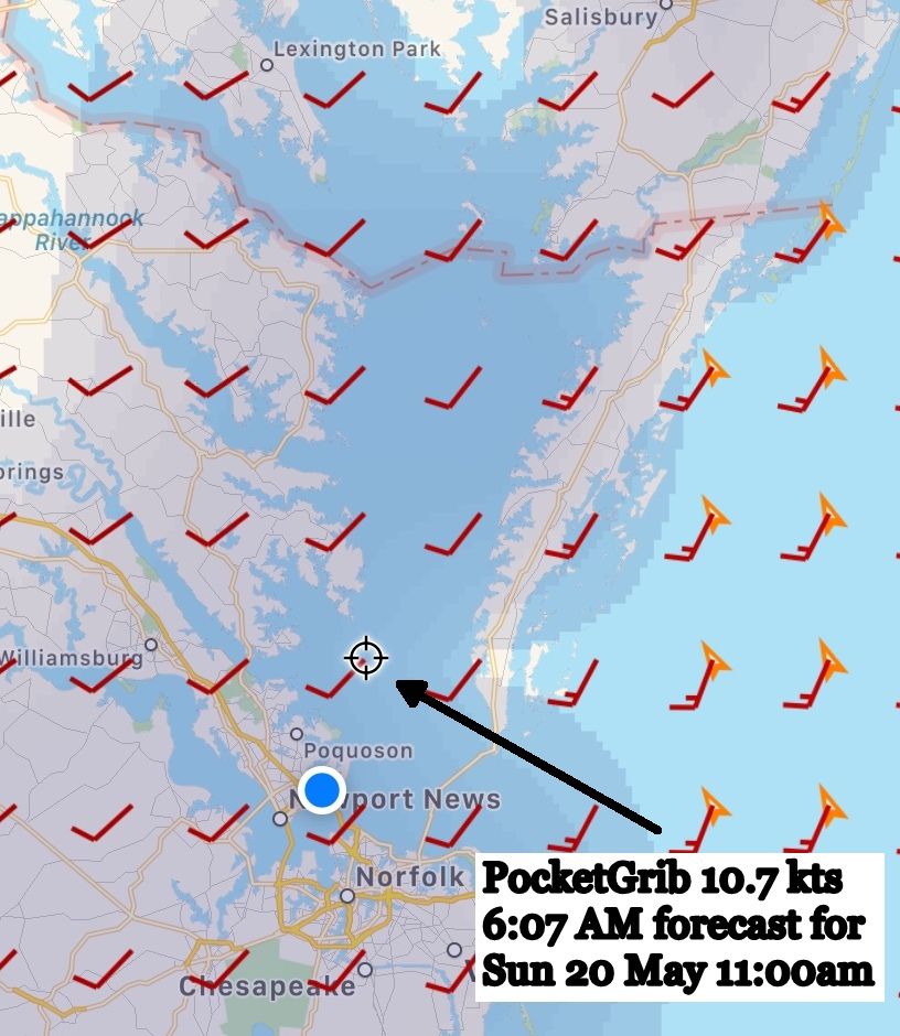
PocketGrib has been my long-time favorite ever since I first started down the ICW. It seemed to be more accurate than the NOAA forecasts, but it has fallen out of favor given my access to other apps that do a better job, although they soak up more internet bandwidth.

Here it's predicting 10.7kts. That's much less than what I observed of 13.6kts as an average around 11:00 AM.

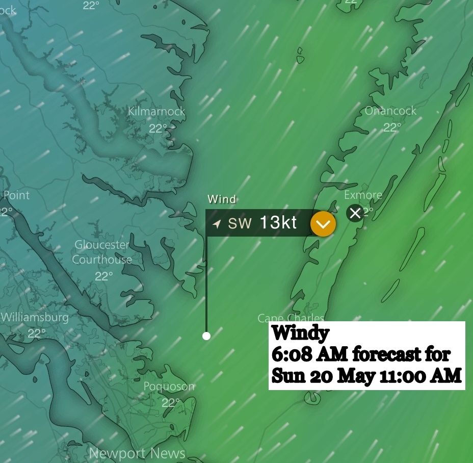
Windy is shown next and the prediction of 13 kt winds is right on target. At the time I was not aware of Windy's ability to predict gusts, so all that is shown here is average wind. For the tests going up the New Jersey coast, gusts will be included for Windy.

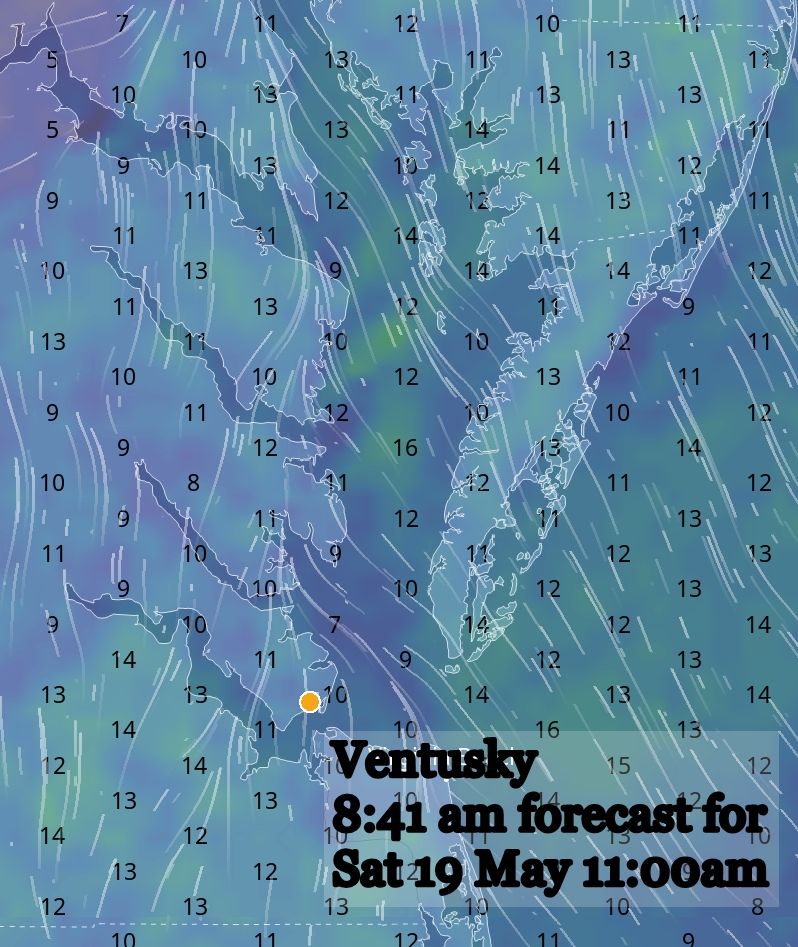
Ventusky shows winds in the same range as the rest, but only 10 kts where I was traveling.

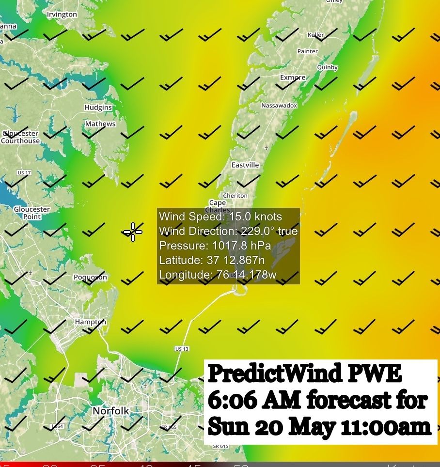
PredictWind shows a forecast of 15 kts for the 11:00 AM timeframe. It's higher than the York Spit buoy but closer to what I observed on our vessel Fleetwing, which was 15 to 19 kts.

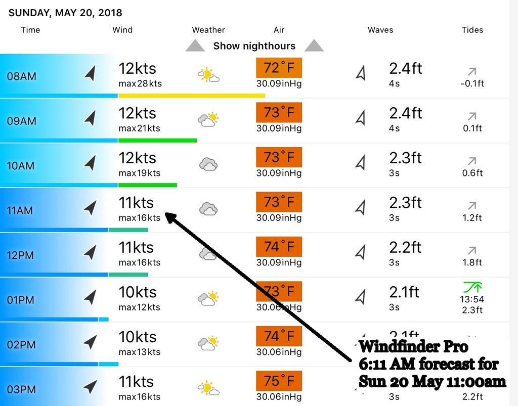
Windfinder Pro predicted 11kts with gusts to 16kts. Not bad.

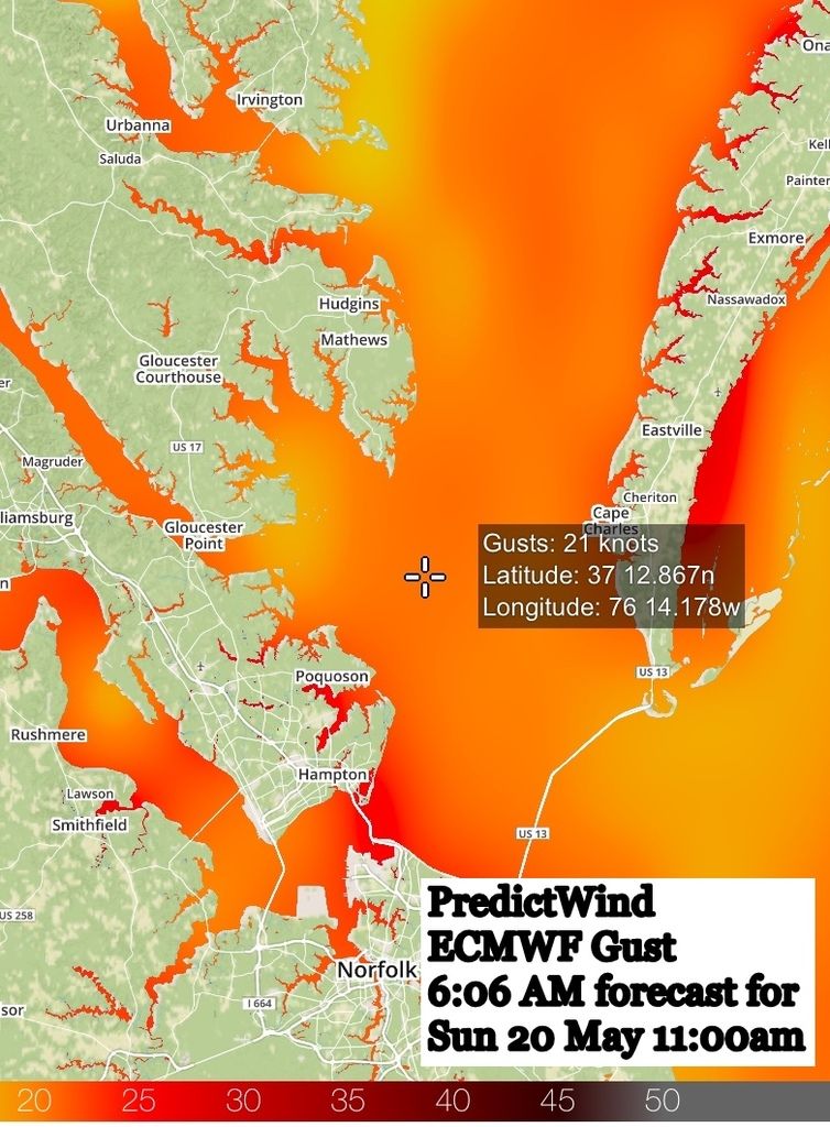
PredictWind showed 21 kts for gusts, which was more accurate for what I encountered en route. However, it's based on ECMWF, which is the same model used by Windy for gust prediction, so I have no reason to believe that Windy would have been any different. I will test that on my trip up the New Jersey coast.

So, who won? I think there were two groups, the bottom two were Pocket Grib and Ventusky, which predicted winds around 10 kts. Windfinder was also a little low but better than either of the two in the bottom group. At the top were Windy and PredictWind. Envelope, please?

Winners:  PredictWind and Windy
Second Place: Windfinder Pro
Last Place: PocketGrib and Ventusky

The outcome could be debated since we're talking only a few kts between the bottom and top group, but four to five knots can mean a significant difference. A 14-kt wind puts twice the force on your boat as a 10-kt wind, not to mention the difference in wave action. So, having accurate forecasts and knowing what to expect often means the difference between a sporty day on the water or a miserable one for sail or power.

The rest of Chesapeake Bay is coming next week, and then the trip down Delaware Bay followed by the trip up the coast of New Jersey. Stay tuned for the final rounds of this shootout. Comments welcome!

Comment Submitted by Rex - June 11, 2018
Robert, great assessment of this group of apps. My understanding is that essentially all the apps provide the raw model output. In some cases only the GFS model, usually for the free apps. The more sophisticated apps, and usually those that charge a fee, may include a number of other models as options for viewing. But in any case, the raw model output. Forecasters always warn against using raw model data alone. When on the ICW I daily read the NOAA discussion provided by the meteorologist at the local forecast office. They regularly point out major disagreements among the various models and often use their own judgement to interpolate or choose among them. They are obviously not always correct in their judgements, but I'd rather rely on their experience than try to use my own judgement. Of course, the models differ the most when the systems we are all trying to predict are at their most unpredictable - and this Spring had been very complicated, with constant change. In other words, when we most need a good forecast, it is most difficult to predict. I suspect that in settled weather, all these apps would be in general agreement and in sync with NOAA marine forecasts as well. But with rapidly moving fronts, highs and lows, I doubt any of the raw models will be consistently accurate, hence the same result for the apps reporting the data.
Comment Submitted by Robert Mersereau - June 10, 2018
PocketGrib show gust data on the Meteogram view.
Comment Submitted by Buddy DeRyder - June 8, 2018
Bob, I question the southwesterly boat heading of 208° of the 23kt wind screen shot if you are heading northerly to clear Wolf Trap. Usually, York Spit NOAA buoy is on a rhumb line of about 8° leaving Back River for Wolf Trap.
Comment Submitted by Ed - June 7, 2018
Bob: Another good article. Thanks. Here are my comments about Chesapeake Bay. I was waiting for you to get to the Chesapeake Bay to see how you dealt with the forecasts and other details here on my home cruising grounds. NOAA’s zone forecasts and marine forecasts consistently underpredict. I don’t know why. I started adding 5-8 kts to their zone forecasts about 15 years ago and still do today. And I always look at the Marine and Aviation forecasts for important details. However, I only adjust their forecasts after assessing the regional situation specific to frontal passage, location of pressure systems and any associated gradients. I also evaluate temperature (diurnal heating) and what side of the Bay I’m cruising on. Finally, I look at the zone forecasts all around me to see if there are large variances, which helps me understand where the boundaries may be. The Chesapeake Bay OFS Wind Forecast Guidance animation (link here) is my go-to when looking out a day, or so. I don’t depend on apps because I don’t know what logic or evaluation is being conducted by the people behind the curtain (say Wizard of Oz.) I think I have NOAA figured out by adding 5-8 kts. The one factor that I see on Chesapeake Bay during cruising season is what I loosely call “thermals.” That is, air that is moving from warm or cool areas to cool or warm areas, respectively. There are so many slots on the Bay (rivers on the western shore) in the landmass that as the heated air rises and creates seabreezes and landbreezes those are simply are not forecast by NOAA very effectively. Basically, I can count on sailing in the morning and in mid-afternoon as the energy from the thermals manifests itself. Not every day – but when there’s other energy (front passage, shortwave along a frontal boundary, a far-away storm system, etc.) I factor that in to the wind equation. And while I enjoy a good North breeze when sailing, I don’t even think of taking the Trumpy out in the Bay if the forecast is for N or NE. There’s too many miles of fetch and that wind direction often bodes discomfort.  Although I hankered for it with my Tartan 33 for the dozen years I sailed her.  
Comment Submitted by Craig McPheeters - June 7, 2018
Hi Robert.  I tried to find an email for you and my googling skills are failing me, drat.  A review which included LuckGrib in the fall would be fantastic. NOAA provides an amazing amount of forecast data for our waters, some long term, some short, some high resolution, statistical blends of many models - what they offer is very impressive.  CMC up in Canada also provides some great data.  Europe is less fortunate, but the German DWD is providing a lot of public domain data.  In LuckGrib I'm trying to provide convenient access to as much of it as I can (although there is so much I need to be a little selective.)    In around mid July, NOAA is planning on upgrading their RAP and HRRR models - they expect the upgrade to improve the 10m wind forecasts.  Also worth checking out is the 'simulated radar' parameter in some of the models which help forecast convection (find this in HRRR, NAM, RAP.)  Feel free to contact me for more info.
Comment Submitted by Robert A Sherer - June 6, 2018
Tim, I was hoping the apps would help, they seem to do so some but but not as much as I hoped.

Craig, when I first looked at LuckGrib after a suggestion for the Round 1 event, it appeared to be just another GFS grib file. I didn't realize it had all the other models, especially the finer resolution ones for Chesapeake Bay. That, plus the $20 buy-in price deterred me from including it.  I'll spring for the bucks and include it in the future but the testing will be in the fall on my next trip down the ICW. Thanks for explaining the details of the app.

Jim, I was using the name displayed under the icon when shown in the iPad choice of apps which is just "Windy". However, you are right. When I accessed the iTunes store under "Windy", the "Windyty, SE" shows up next to the Windy icon. That's the one I downloaded.  https://itunes.apple.com/us/app/windy-wind-and-waves-forecast/id1161387262?mt=8

Comment Submitted by Jim Healy - June 6, 2018
Hi Bob, Just to clarify, the app to which you refer as "Windy" is , by Windyty, SE, right?   There is an app called , by Windy Weather Worldwide Inc.   The only difference between them is not the names, it's the Icon for the program... Jim
Comment Submitted by Craig McPheeters - June 6, 2018
You should add LuckGrib to your app list!  It presents the weather model information in a very clear and informative manner.  It also supports many weather models, which you can download directly via the app.  For the Chesapeake Bay, it has four global models (GFS, GDPS, CMC ensemle, GFS ensemble) as well as five regional models, all much higher resolution than the global models (NAM, RAP, HRRR, HRDPS, NDFD.)  NAM and HRRR are available with a 1.62nm resolution.  LuckGrib is available on macOS, iPhone and iPad.
Comment Submitted by Tim Tiernan - June 6, 2018
Great article. I have seen the same inaccuracies often.  Anecdote: Prior life as a airline pilot, made numerous arrivals over eastern Long Island and watched the development of the sea breeze, specifically over Gardiner's Bay. Tried to see the pattern of wind development, to be the fastest sailor on the bay. Retired after 29 years and still don’t have a clue other than in the most general sense!
Explore More News & Articles In Specific Cruising Areas
Recent Videos
Plan Your Boating Adventures with Waterway Guide
Waterway Guide's new Mobile App on iPad Mini with maps, data links, and downloadable guide books
Fuel Prices for Boating at Waterwayguide.com
Purchase a Guide
  • 4,000 Marinas
  • Thousands of anchorages
  • Updated Charts
  • Mile-by-Mile Navigation
  • Highlighted Alerts & Cautions
  • Full-Color Aerial Photographs
Download The App

The Waterway Guide App Makes it easy to leave reviews, use our explorer, and view waterway guide materials all on the go!