
Editor’s Note: Predicting weather and interpreting data from the numerous computer models used by meteorologists is tricky business. Added to that is the way in which various weather apps present information along with the timing of their updates. In this review of four weather apps, Contributing Editor Bob Sherer conducted a simple evaluation based on his experience on a particularly windy day.
Hank Pomeranz, noted yachtsman, former Navy meteorologist and navigation expert from Southport, NC, reviewed this article before publication. Hank’s observations of this evaluation included insight into recognizing that the multitude of variables in forecasting make it difficult to trust any app, or computer model. Nonetheless, weather reports and apps are valuable for all of us. Let us know what you think.

Where did this 20-knot wind come from? As always, it’s right on the nose. NOAA never predicted it - they said 5 to 10 kts!
Ever have this happen to you? I’ll bet not a single boater answers “no” to this question. What’s interesting about this event is that only one of four popular weather apps predicted the wind correctly, and even the NOAA Coastal Forecast missed the boat!
In my ever-widening quest to find the perfect weather app (it doesn’t exist), I bought four of the most popular apps and have begun testing them against each other, along with the NOAA forecast, as I head north this spring.
Each of these apps predicts more than just wind. They also include waves, clouds, rain, temperature, etc. But for this article, I’ve focused only on wind. This is my first report and is based on conditions we experienced on April 5, 2018 leaving Rodriguez Key for Miami, FL.
My evaluation format is simple: record the prediction of each app and the NOAA Coastal Forecast and compare them to what actually happens. (If anyone wants to recommend another app for this exercise, please let me know.) The sample size of weather events is just this one day; not a large enough data set to make an empirical-based decision, but the information and observations are real. I’ll conduct further tests as I head north. Perhaps one app, or the NOAA Coastal Forecast, will continue to stand out. We’ll see. Here are the apps I’m using:
PocketGrib was my first weather app and I have come to depend upon it over the years for coastal cruising. It provides forecasts every three hours for up to eight days in advance, although it will interpolate to every hour if needed. PocketGrib uses the GFS (Global Forecast System) computer model, which is provided free of charge by the National Weather Service (NWS). It is the easiest of all the weather apps to use and the data files are relatively small. The app costs $5.99.

Ventusky is from a Czech meteorological company based in Pilsen. It displays the wind with streaming dots like Windy. One difference is that Ventusky overlays the screen with a grid of numbers showing wind speed, a handy addition. It uses several weather models including GFS but does not have ECMWF, the noted European model that Windy has. Ventusky costs $3.99.
 Windy is a very popular weather app with more options and capabilities than PocketGrib. It shows the wind as a streaming series of dots, almost hypnotic and pleasing to the eye. It has all the best weather models to choose from: ECMWF, GFS, NEMS, NAM, and ICON. The GFS is the same model used by PocketGrib. The ECMWF is the European model that many consider the gold standard. You can Google the acronyms to find out more. I used the ECWWF model in these tests. From the developer of Windy: “Our goal is to provide best weather forecasting service in the world. So far, we have failed to find a sustainable business model.” In other words, it’s free.
PredictWind is from the weather team manager of Alinghi – winner of the America’s Cups in 2003 and 2007. The parent product was developed for America’s Cup races. It uses four models: ECMWF, GFS, and two proprietary models: PWG and PWE. I used PWE for the predictions in my assessment. It’s based on the European ECMWF, but with tweaks learned from Cup racing. The app is free to download but requires a subscription of $28.99/yr.
Now, back to the morning of April 5, 2018. Our first duty every morning of a leg is to look at our weather apps.
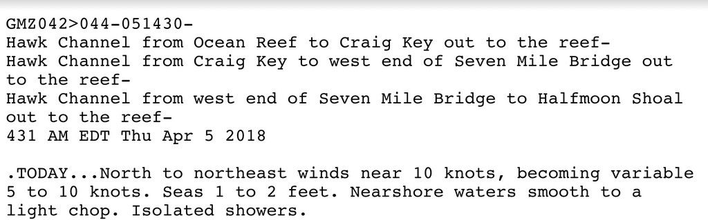
First up was the NOAA weather report. That was what we expected from the previous night’s report, good news. Anything less than 10 kts is fine from any direction, especially if it’s going to die off in the afternoon.
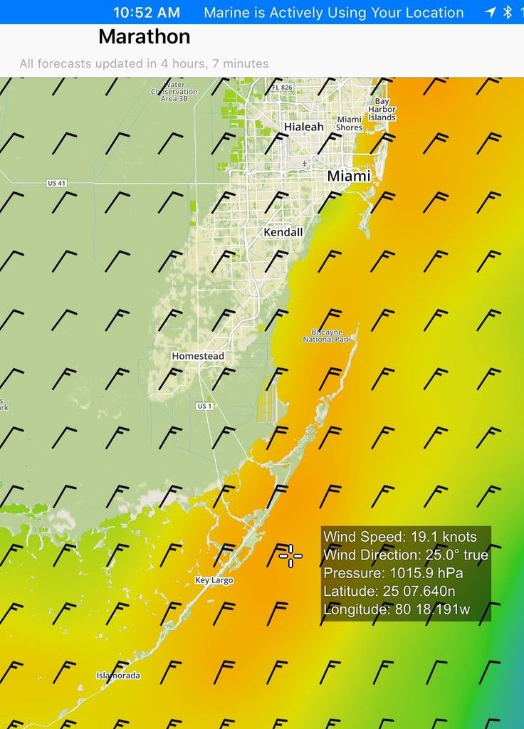
Next is the PocketGrib forecast for 11:00 am. At this point, we would be about two hours out of entering the Cape Florida Channel. It agrees with the NOAA forecast, nothing over 10 kts. Looks like a go. If high winds were predicted in the afternoon, we would duck into Caesar’s Creek and either stay there overnight or go up Biscayne Bay to Marine Stadium. So, we had a choice if the weather was not to our liking. However, this forecast said it was good for an outside run to Miami, which we would reach by 1:00 pm.
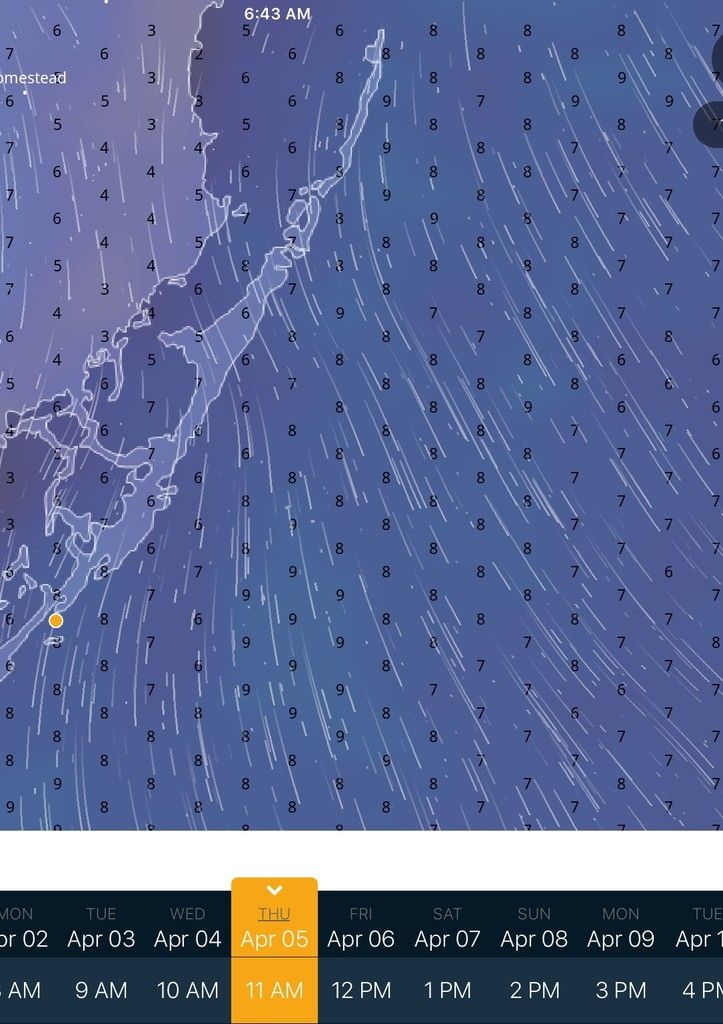
Ventusky is next. Note that the wind prediction still indicates nothing over 10 kts.
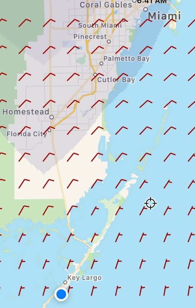
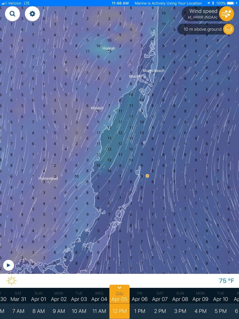
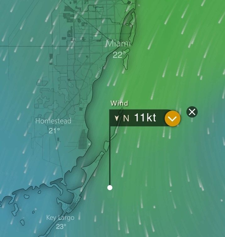 The Windy forecast for 11:00 a.m. up near Miami shows 13 kts. This was a little troubling. But then 11 –13 kts. is still okay and it was calmer prior to 11:00 a.m.
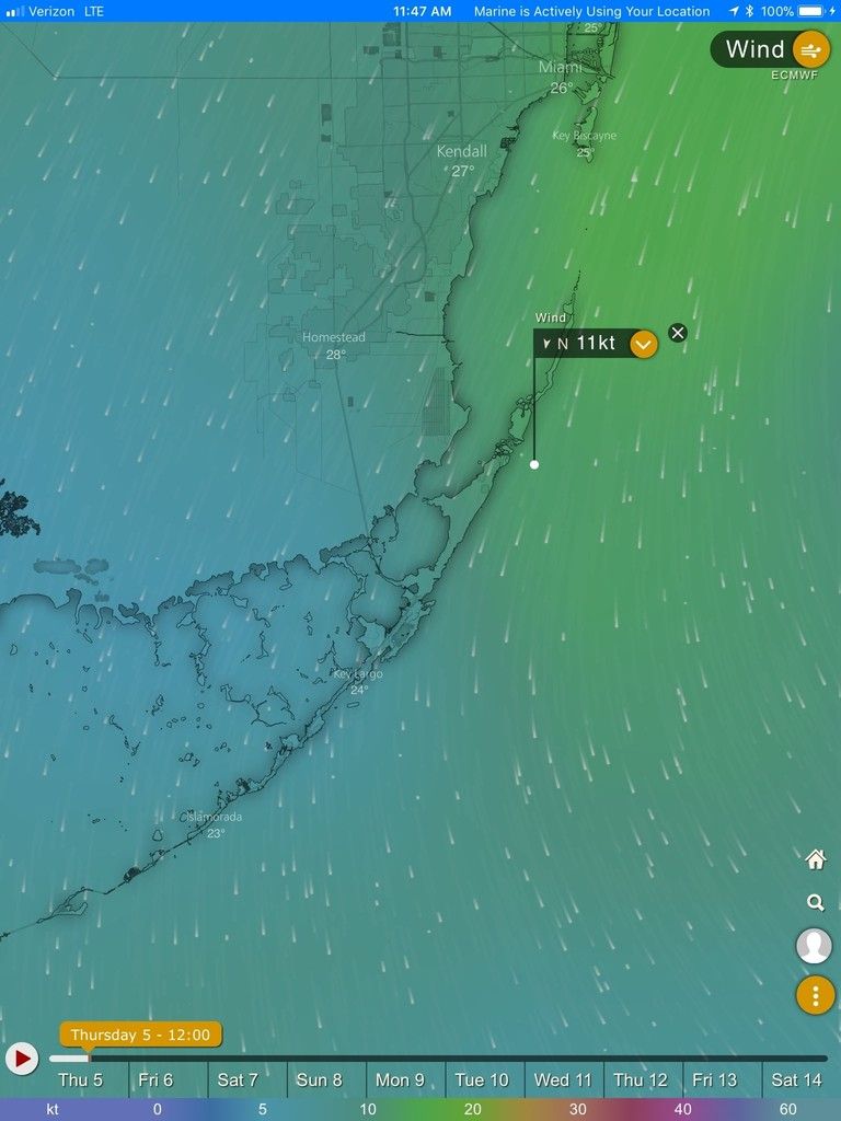
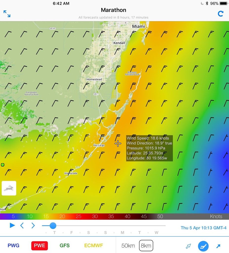 The PredictWind forecast was disturbing. It showed winds of 20 kts. developing late morning. The challenge now was whom to believe?
We wanted to go outside all the way to Miami since it would be faster without the detour through Caesar’s Creek. We had reviewed the NOAA forecasts (by humans) and four apps that present the information with seemingly no human intervention. So, we assessed the situation and allowed hope to overrule the one troubling report of high winds and went outside. By the time we reached the Caesar’s Creek entrance the wind had not yet kicked up, so we moved on. Mistake. Besides, PredictWind was still relatively new to me and my tried and trusted PocketGrib said everything was going to be okay. Once past Caesar’s Creek, I brought up the latest NOAA coastal forecast and sure enough, they had changed it from 10 kts. and decreasing to 5 to 10 to a new forecast of 10 to 15 kts! Thanks a lot NOAA, but by that time I didn’t need a forecast to see the increasing winds speeds.
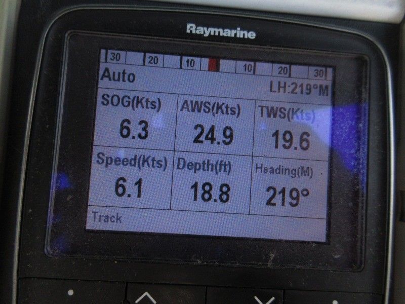 So, what really happened? Here’s a photo of my wind gauge at 11:30 a.m. The wind was on the nose, spray was coming over the bimini and washing down the dodger and ahead was a sea of whitecaps. This was not a storm; there was no rain, just wind.
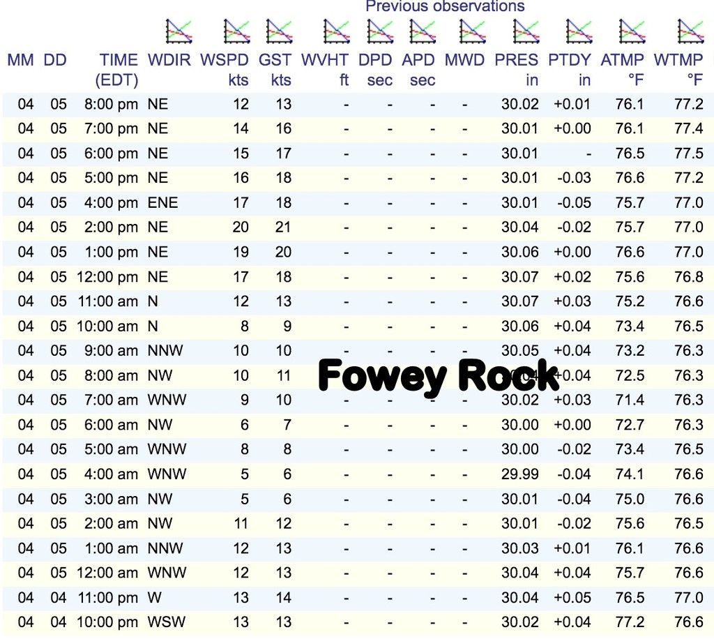
From the Fowey Rock readings, you can see the winds started around 11:00 and peaked between 12:00 and 2:00 p.m. around 20 kts.
What was displayed by the apps real time? I gave each one another chance at 11:47 to show actual conditions at 11:45. In other words, tell me what’s happening right now. Did they correct themselves?
 PocketGrid (not shown) and Ventusky were out for a lunch break.
 Windy was a little closer.
PredictWind was dead on.
For this round, I’ll give first place to PredictWind, second to Windy, third to NOAA Coastal Forecast (at least they corrected themselves later), and a tied for fourth to PocketGrib and Ventusky.
Of course this does not mean that PredictWind is the best app. There is a lot of weather ahead and we’ll see who comes out on top in the long run. I will continue grading the rounds and perhaps at the end of the cruise, I’ll issue an update on who’s the winner. If anyone wants other weather apps to be included, please comment and let me know what app you think should be included. It would also be interesting to have a person’s forecast included in the boxing rounds. Any volunteers?
We have some exciting weather tests ahead that include the Chesapeake Bay, Delaware Bay and up the coast of New Jersey. I will focus on those days when there is variability in the predictions like the example I showed in this article, so we get a true test. After all, we all want to know the weather – and the best app or service to predict it.


- 4,000 Marinas
- Thousands of anchorages
- Updated Charts
- Mile-by-Mile Navigation
- Highlighted Alerts & Cautions
- Full-Color Aerial Photographs

The Waterway Guide App Makes it easy to leave reviews, use our explorer, and view waterway guide materials all on the go!


