Post Your Own Nav Alerts on the Waterway Explorer
Date Posted: October 20, 2016
Source: Ed Tillett, Editor-in-Chief & General Manager

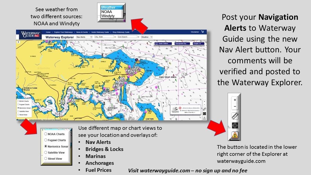
You can now post Navigation Alerts and observations anywhere on Waterway Explorer. Your comments will be verified and available on the web app for everyone to see. Please provide as much detail and accuracy as possible.

We’ve also included weather overlays from two sources, NOAA and Windyty. 


NOTE: DO NOT POST NAV ALERTS AS COMMENTS TO THIS ARTICLE!

You must submit nav alerts on the Explorer as outlined above, otherwise other boaters will not be able to view and learn from your experiences.

Comment Submitted by Richard Simmons - April 10, 2020

Florida ICW Bridge Palm Beach SR700 Southern Blvd - under construction - clearance limited to 65' 

Comment Submitted by George Bostick - May 24, 2019

Come visit our LaBelle Florida City dock on the Caloosathachee River in Hendry County, Fl free 3 nights, 30/50 amp power Free, Fresh City Water Free.  Barron Park 2 minutes away on the River, City Library next door and a excellent Resturant/Bar 2 minutes away.

Comment Submitted by THOMAS FIORENTINO - March 29, 2019

Carolina Beach Inlet Carolina Beach NC.  is closed due to shoaling. Coast Guard reports there pulling all marker bouys till further notice. Not a very good Inlet without local knowledge anyway but avoid until bouys reset after dredging. 

Comment Submitted by Ron Akke - September 9, 2018
  The Great Bridge Bridge was struck by lightning Saturday evening, 9/8/2018, causing electrical issues that require the bridge to be opened manually. While crews work on repairs, the bridge will lift at 6am and 6pm to allow the passage of marine vessels. These openings could last as long as an hour, depending on marine traffic. Road traffic should choose an alternate route during those times and expect delays in the area.   All the bridges, locks and commercial traffic in the Norfolk, Chesapeake Virginia Beach area monitor marine channel 13  
Comment Submitted by Peter Ohanian - July 25, 2018
Beware, unmarked obstruction.  Between green markers 139A and 141 on the Oneida River just west of  Oneida Lake.  It is shallow water.  However, there is an obstruction between the markers on the edge of the channel.  I know because I hit it and damaged the prop.  The local service yard confirmed that there is something there because others have hit it.  They notified NY canals to move the channel markers to no avail.
Comment Submitted by SCOTT MCCONNELL - March 10, 2017
Do not!!!! Use the mooring balls at French Leave Marina and resort. There are supposed to be 5 one was gone when we got there Feb 3rd. One broke off on our buddy's boat and one broke off on us two nights latter!! Management is aware and as we left they were trying to get a diver to fix them. Call resort before any attempt to use them! The resort was very concerned and made it right financially but we almost lost one of the boats!
Explore More News & Articles In Specific Cruising Areas
Recent Videos
Plan Your Boating Adventures with Waterway Guide
Waterway Guide's new Mobile App on iPad Mini with maps, data links, and downloadable guide books
Fuel Prices for Boating at Waterwayguide.com
Purchase a Guide
  • 4,000 Marinas
  • Thousands of anchorages
  • Updated Charts
  • Mile-by-Mile Navigation
  • Highlighted Alerts & Cautions
  • Full-Color Aerial Photographs
Download The App

The Waterway Guide App Makes it easy to leave reviews, use our explorer, and view waterway guide materials all on the go!