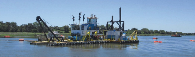
The Atlantic Intracoastal Waterway (AICW) has received much attention this past year. As a result, it’s in the best shape it’s been for the past 10 years. Major funding increases for dredging has improved the depths through some areas that haven’t been dredged in decades, in addition to routine dredging for places like Lockwoods Folly and Shallotte. In no previous year would you have seen such a long list. Through the efforts of the Atlantic Intracoastal Waterway Association (AIWA), local agencies, U.S. Army Corps of Engineers and others, funding to maintain the beloved Atlantic ICW was at its highest this past year over many previous years.
Let’s take a trip down the Atlantic ICW and discuss what’s been dredged in the past year. Remember to click on the underlined Waterway Guide link for full details and an update as conditions change. If you’re a long time ICW cruiser like I am, the list makes your heart glow.
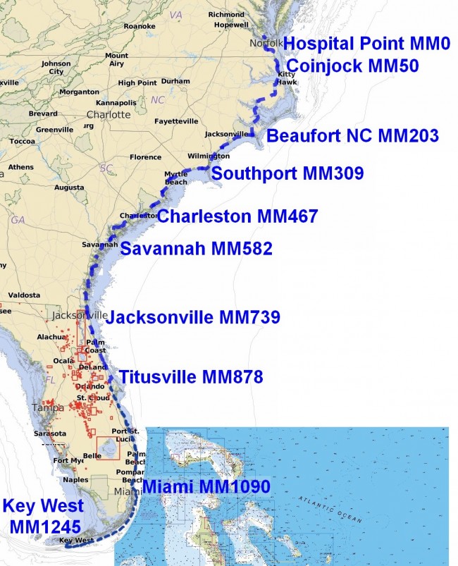
Browns Inlet at MM 238. Now it’s a straight shot through for 10 MLLW although the ATONs haven’t been moved as of 8/29/2019.
Lockwoods Folly at MM 321.This was a bear of a problem in the fall and it has since been dredged. However, in just a few months, it has started to shoal in again and we’re back to the old dogleg route by the northern shore, the same route we took before dredging! The dogleg route is still good for 8 MLLW, but be sure to study the chart in the link since the route takes a few twists and turns not marked by ATONs.
Shallotte at MM 330. It was dredged last year and it’s held up pretty well, it’s a straight shot through at 10 MLLW, just follow the ATONs.
Dewees Island at MM 452. It’s located just north of the Isle of Palms by G99 to R104. It’s now deep and wide to 10 MLLW
Isle of Palms at MM 460. Dredging has just been finished this month and it’s in good shape for the fall migration at 10 to 12 MLLW.
Dawho River at MM 496. Dredging was completed last year to 10 MLLW. There are two paths through the area: a southern path that follows the dredging and a northern path that’s shorter and straighter. I recommend the northern route but either one can be taken. See details at the link.
Watts Cut at MM 503. Also dredged last year but has started to fill in some, down to 6.7 MLLW in the spring.
Fenwick Cut at MM 511. It was dredged last year but has started to shoal near the northern entrance by R162A to 7 MLLW.
Ashepoo-Coosaw Cutoff at MM 516. This area was the first one to be dredged last year and it has shoaled in some, down to 6 MLLW at the southern section. It’s important to stay in the middle but, unfortunately, it’s not the visible middle. There’s a GPX route available for downloading off the Waterway Guide link that will keep you exactly in the center of the dredged channel. If you go through at low tide, following it could be a big help.
Fields Cut at MM 575. It’s due to be dredged before the fall migration but it’s not dredged yet. Check the Waterway Guide link before going through.
Hell Gate at MM 601. Dredging is due to underway by 8/26 to be completed by 10/1/2019 so it’s not dredged yet and you will encounter dredgers along the way. Check the Waterway Guide alert link for updates.
Buttermilk Sound at MM 661. The channel was just dredged this August to 12 MLLW and 150 feet wide. Just follow the ATONs.
Jekyll Island Creek at MM 683. This is the one everyone’s been waiting for! The shallowest area of the ICW has finally been dredged to 10 MLLW. However, it’s been dredged to only 75 feet wide so you have to be very careful to stay in the dredged channel. The best way to do this at low tide is to follow the GPX route you can download from the Waterway Guide alert link. It helps because the dredged channel is to the east of the old channel and not obvious from the ATONs.
South Amelia River at MM 728. Last fall you had to pass R44 on the wrong side for the deepest water but not anymore. It has been dredged to 13 MLLW between the two buoys.
South Amelia River at MM 729. The turn towards Sawpit Creek has been dredged but not the entire area. For some reason, a 5 MLLW area was left that could catch you if you aren’t careful. Look at the chart in the Waterway Guide link.
Sawpit Creek at MM 731. Before dredging, you had to follow the outside of the bend for deep water but now it’s a straight shot through for 12 MLLW. Just follow the ATONs.
Matanzas River at MM 796. The channel by R86 is being dredged.
Ponce de Leon at MM 839. You used to hold your breath running by the two reds here, no more. Now it’s at least 10 MLLW.
Ponce de Leon at MM 843. The dredging here cleared a 10 MLLW path. It will shoal up again since this is an active shoaling area but it’s good for now. Be sure to check the current status at the Waterway Guide link before going through.
New Smyrna at MM 845. The old ICW was dredged a couple of months ago but it’s easier to just take the Sheephead Cut for 12 MLLW.
Ft Pierce at MM 966. The dredge just finished work in this area, good for 10 MLLW.
St Lucie at MM 986. It was shoaling to 6 MLLW through here but a dredge is on-site and should be completed by the fall migration.
Palm Beach at MM1024. A five-mile section of the ICW is was dredged to 10 MLLW.
All this is very good news for sure, however (you knew that was coming, right?), there are still many areas not worked, 69 locations in all. On top of that list is Little Mud River at MM 654 with depths down to 4.4 MLLW. We will have to wait for more funding to clear out that area. Also coming to mind is New River at MM 244. There is a path that snakes through the buoys that’s best followed by loading a GPX route from the Waterway Guide alert in the link given for New River. I could go on for quite a bit but a complete list of the rest of the 67 hazards and alerts can be accessed at 2019 Fall Waterway Guide Alert List. It’s ordered from north to south with a mile marker for each alert and a link for full details. It’s meant to be a convenient list to consult before setting out for the next day’s adventure on the ICW.
For all the details of the cruise south, there are two guides of interest. First, there’s the Waterway Guide Atlantic ICW 2019 Edition which features mile-by-mile navigation information, aerial photography with marked routes, complete marina listings and locator charts, anchorage information, and expanded "Goin' Ashore" articles on ports along the way. The 2019 ICW Cruising Guide by Bob423 is a companion guide that covers all the shoal areas in detail and how to safely navigate them along with a few favorite marinas, anchoring spots and some personal tips.
On your adventure, consider contributing your observations to the cruising community by making input to an appropriate Waterway Guide alert or by posting on the ICW Cruising Guide Facebook page. There is nothing like on-the-spot reporting to keep everyone abreast of the changing shoals of the ICW and you’ll be contributing to keeping all the friends you make along the way “out of the mud.”


- 4,000 Marinas
- Thousands of anchorages
- Updated Charts
- Mile-by-Mile Navigation
- Highlighted Alerts & Cautions
- Full-Color Aerial Photographs

The Waterway Guide App Makes it easy to leave reviews, use our explorer, and view waterway guide materials all on the go!


