
View on Waterway Explorer link
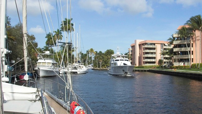
Many different bodies of water could be in the running for this dubious prize, and I am sure no matter which ones were nominated the arguments could continue for days. My vote is for the New River in Fort Lauderdale, FL that runs from the Atlantic Intracoastal Waterway (AICW) inland through downtown Fort Lauderdale. It is not the geography that is the biggest problem, but man-made challenges. The waterway is narrow, and very crowded, frequently with large vessels transiting.
The river is the only access to a large number of marinas and boatyards, many of them specializing in large yachts. This is both the primary reason for transiting this river, and also the reason it can be so challenging. How do you deal with a 180-foot super yacht coming at you around a blind turn when she has a following current, can't stop, and can hardly steer? A classic case of "good news/bad news" is that most of the large boats moving on this river are piloted by professionals who are familiar with the area. The good news is that they are unlikely to do something foolish and are quite considerate of other boats around them. The bad news for newcomers to the river is that they have their own shorthand and "secret codes" when communicating with each other. Mysterious and confusing to the uninitiated, indeed. But once you know what they are talking about it gets easier.
A few observations:
- There will be times you will need to wait for other boats, or for bridges. You MUST be able to hold station with your boat in a current—maybe pointed forward or maybe astern.
- If you have a longer boat, a bow lookout is helpful in giving advance notice about what might be lurking around any of several blind corners.
- You will be using the radio to communicate with other boats and bridge tenders. Polite and concise conversation is appreciated by everyone.
- If you are new to this, it might be a good idea to have someone other than the person manning the helm working the radio. In an ideal world, there would be one person running the radio, one steering, the Skipper coordinating everything, and a lookout on the bow.
- You and your crew need to be aware that this transit will require close concentration and the full attention of the person on the helm. This is one place where small talk and commentary on the passing scenery are probably best saved until later.
- It will be much better overall if you plan your trip to go against the tide. This makes holding station while waiting for traffic or other boats much easier.
- Many of the largest vessels will be transiting the river under tow, with small tugs front and back.

On the Radio
A word about radio etiquette. All the opening bridges in the local area use VHF Channel 9 as the contact channel, and there are a lot of bridges. Boats transiting the New River also use Channel 9 to coordinate passing arrangements. Most days Channel 9 is going to be very, very busy. Avoid idle chatter on the radio. It takes care and close attention to avoid stepping on other boats' radio conversations. Keep your comments as short as possible. Use low power on the transmission. Nobody 25 miles away needs, or wants, to hear your request for a bridge opening. If this is a new experience for you it can be helpful to spend a couple hours nearby with the radio on so you can hear the local style.
For instance, a standard by-the-book call to a bridge for an opening in an area with light radio traffic might sound like this:
Boat: "Davie Boulevard Bridge. Davie Boulevard Bridge. Davie Boulevard Bridge. This is Harmonie. Over"
Bridge: "Harmonie, this is the Davie Boulevard Bridge, Go ahead."
Boat: "Davie Boulevard Bridge, we are the southbound sailboat and request your next opening. Over."
Bridge: "Harmonie, Next opening is at 10:15. Please stand by."
Boat: "Good copy. Harmonie standing by on zero-nine."
All that is all appropriate and clear but takes far too much precious radio time on the New River. This is normally what you will hear and should expect to imitate:
Boat: "Davie Boulevard Bridge, this is Harmonie, southbound sailboat requesting your 10:15 opening."
Bridge: "Copy that Harmonie."
That abbreviated conversation leaves a lot more time for other boats to get their messages in the queue. As the larger yachts and working vessels transit the New River they will broadcast "Securité" messages at regular locations, so everybody knows what is coming. The typical format for such an announcement is like this:
"Securité, Securité. This is the 53-foot sailing vessel Harmonie inbound at the Girl's School. Standing by on zero-nine for any concerned traffic."
Again, short, simple and clear. It helps to remember that many of the skippers on this river work here every day and know each other well. They communicate with each other in very few words. As you transit such a crowded waterway, it is your responsibility to listen for, and keep track of, the other boats as they make Securité calls and bridge opening requests. The objective of all this broadcast information is so boats can avoid meeting at places on the river where it is too narrow to safely pass. If you do a good job at keeping track of who is where, then passing arrangements can be made quickly and efficiently.
You absolutely should be listening to Channel 9 as you transit the New River; but should you be issuing Securité calls? That is always a matter of judgement. As boats get bigger and less maneuverable, the radio calls announcing position and intent become more important. Sometimes the most important thing you can do is to let everyone else know that your radio is on, and you are listening. Our boat is a 53-foot monohull sailboat and if we were to come upon a 150-foot motor yacht in a narrow stretch of the river, it would be difficult at best, and dangerous at worst. Therefore, we always issue Securité calls.

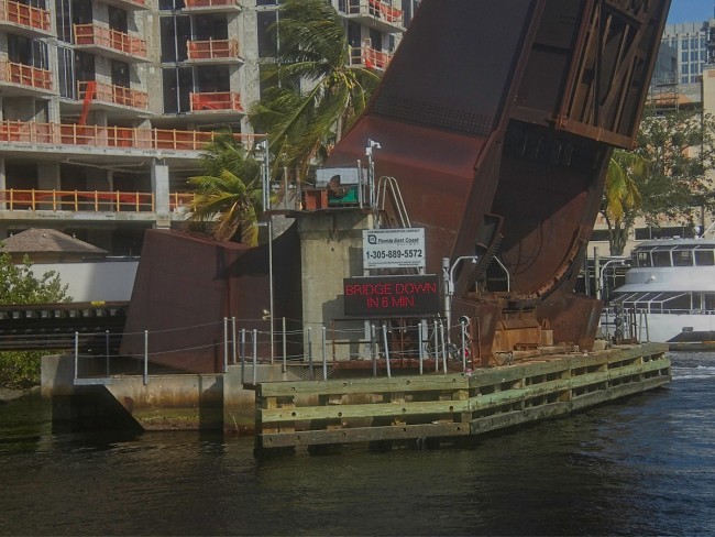
Bridges
Bridges on the AICW around the New River open either on the hour and half hour, or at 15 and 45 minutes past the hour. As the clock swings past those times for several minutes there is a steady stream of conversation between boats and bridge tenders. Bridges on the New River itself open any time on request at the discretion of the bridge tender, except they do NOT open on weekdays from 0730 to 0900 and from 1630 to 1800 hours. Plan ahead so you do not get stuck. Bridge tenders on such a busy waterway have a difficult job. Be patient with them, they have a lot of concerns to juggle. If you are polite and respectful to them, they will get you through as soon as they can. There will be times they have to delay an opening while heavy automobile or pedestrian traffic, maintenance crews, or emergency vehicles clear the bridge. They will appreciate your patience. To add to the fun, there are railroad bridges as well. They normally stand open and do not have an on-site tender but are automated. Watch the signs. Recently the Florida East Coast (FEC) Railroad Bridge added a radio announcement of closings in addition to the signage. This has been helpful getting skippers advance notice of the bridge status. Finally, if you have radio antennas, outriggers or other appendages that can be folded down, be sure you do so before requesting a bridge opening. Requesting an opening that could have been avoided by a vessel dropping or moving its adjustable hardware is a $1000 fine in Florida. Each of the bridges has a tide board showing the minimum clearance. As a general rule, if you call the tender to ask if you will fit under the bridge they will refer you to the tide board rather than making a decision for you.
A Confusion of Names
One of the most confusing parts of a New River passage is trying to figure out what on earth the captains are talking about as they discuss where they are and what they are doing next. Some things you can figure out from the chart. For example, "Tarpon Bend" is marked on the local NOAA charts as a sharp dogleg in the river where the Tarpon River joins. If you look close enough at the chart, you will eventually figure out that "The Tunnel" is where US Route 1 (SE 6th Ave) tunnels under the river. Other names will leave you scratching your head in confusion. "The Girls' School," "Little Florida," "The Wiggles." I thought (silly me) something like the "Girls' School" would be easy to find. Just use Google and search along the river for a school for girls. No luck. A conversation with a local reveals the truth. It turns out there hasn't actually been a girls' school for many years, but the former dormitory is a prominent landmark and lives on in memories of the local boat captains but is documented nowhere. Without the magic decoder ring of local knowledge, you are lost, even if you are paying close attention.

When to Go, When and Where to Wait
First, the Bridges:
Navigation Advice
As we proceed up bound on the New River from the AICW, the first of the useful spots to know is Green Marker #11 at Tarpon Bend. This is a good spot to issue a first Securité call as you head up the river and is a nice wide spot to wait if there is downbound traffic coming around Tarpon Bend. Just upriver from Tarpon Bend is another wide spot at Red Marker #12 which is a good place to meet oncoming traffic.
The "Girls School" and the Tunnel are places with blind turns where large boats will issue Securité calls. Keep an eye ahead as you go over "The Tunnel," you are just one blind turn from being face to face with the 3rd Avenue Bridge. Especially if you are coming up with a flood current pushing you along, the bridge might be an unwelcome surprise for the unwary skipper. Once clear of the 3rd Avenue Bridge, you are only a few hundred yards from the Andrews Avenue span. This can be one of the more harrowing spots in the transit upriver. The approach is narrow, with boats docked on each side.
Just past Andrews Avenue is the FEC railroad bridge. If the Railroad Bridge is closed, Andrews will not open for boat traffic. I have waited there for 20 minutes while three trains crossed. Just down river from the Andrews Ave. Bridge, on the north bank, is a small city park with a colorful building on the river shore. Because there are no boats docked on the north side here, and the channel is a bit wider, it looks like a good spot to hold position while waiting for the bridge. Do NOT linger off this building. It is a pump house for the city's storm drains. Periodically, the pumps turn on and shoot a high velocity stream of water into the river, forceful enough to push around even a 140-foot yacht. If you are first in line for the bridge, keep that pump house a dozen yards in front of you as you wait, certainly you will want to be no closer to the bridge than that. The FEC Railroad bridge now announces its closings on the radio, and also has a lighted sign at the bridge. It is narrow, and suitable for only one large boat at a time. As always, in most circumstances, yield the right of way to boats who have the current behind them. Their ability to maneuver is more limited, and while it is not a legal requirement here in the New River, it is just good manners. Don't hesitate to use the radio and let them know you'll be waiting for them. In some cases, the bridge tender will help coordinate traffic suggesting who should hold, and who should go first. Unless you have a compelling reason to disagree, follow their recommendations.
Once past the FEC Railroad bridge there is a bit of a wide spot as you approach the Performing Arts Center. This is a good place to set up for passing a vessel coming the opposite way. Just past the Performing Arts Center is the 7th Avenue Bridge. Charts and maps will show this as William H. Marshall (7th Ave.) Bridge, but no matter. To sailors it always has been, and always will be, 7th Ave. Nothing special about this bridge, there is room to pass other boats on both sides. Past 7th Ave, the next significant waypoint will be the fork where the North and South branches of the New River come together. There is even a helpful sign to guide you along. Be sure you take the turn to the left when up bound.
Shortly after taking the fork to the left, you come to "Little Florida." This is a place you need to be SURE is clear before you enter. Named for its resemblance to the Florida Peninsula, it is two hairpin turns in a row with a third tight turn, all with very limited sight lines and little room. If there is traffic you need to yield to, you can hold before or after the turns where there is width to pass.
Past Little Florida is "The Wiggles," which is the longest stretch of the river with restricted width for passing. Large boats should be transiting the Wiggles in only one direction at a time. This is not a place you want to meet large oncoming traffic. Once through the Wiggles, there is a wide area before the Davie Boulevard Bridge that makes for easy passing and waiting.
The area just upstream from the Davie Boulevard Bridge is more congested, so if there is traffic on both sides of the bridge it makes sense for the up-bound traffic to hold until everybody gets through down-bound. Normally this will be suggested by the bridge tender but if he doesn't, feel free to suggest it to the oncoming traffic yourself. Once through the Davie Boulevard bridge, you are one turn away from the first, and largest, of the boatyards on the New River, Safe Harbor Lauderdale Marine Center. Although there is plenty of room here, be aware of traffic in and out of the travel lift pits. If you are a large sailboat, you'll be stopping here, since the I-95 bridge is fixed at about 55 feet. If you are going farther upstream, one last Securité call as you approach the I-95 bridge, and make sure the SCL Railroad bridge immediately upstream of I-95 is clear, and you are into Fort Lauderdale's "Marina Mile." Relatively straight, wide and with good sight distances, this shouldn't pose any unusual problems. Congratulations, you made it.
Capt. Bill Kinney, aka "The Fishing Sailor," has lived on a sailboat since 1999, first on the west coast of the U.S. then more recently on the east coast, migrating with partner Karen with the seasons from Maine to the Caribbean keeping the two freezers on the boat stocked with fish. Tuna, grouper, snapper, mahi-mahi and wahoo are favorites in the tropics. Flounder, cod, pollack and haddock are the cold-water selections. Bill is a U.S. Coast Guard Licensed Captain for vessels to 100 tons, a skilled sailor, knowledgeable boat mechanic, photographer and writer. Visit his blog here https://fetchinketch.net


- 4,000 Marinas
- Thousands of anchorages
- Updated Charts
- Mile-by-Mile Navigation
- Highlighted Alerts & Cautions
- Full-Color Aerial Photographs

The Waterway Guide App Makes it easy to leave reviews, use our explorer, and view waterway guide materials all on the go!


